Sunday, June 28, 2009

Roopkund - Ronti Saddle – June 2009

Roopkund - Ronti Saddle – June 2009

Gods decided to descend on the earth as mountains. But the earth asked: “Why do you come in the form of mountains and not in your own form?”. And Vishnu answered: “The pleasure that exists in mountains is greater than that of animate beings, for they feel no heat, nor cold, nor pain, nor anger, nor fear, nor pleasure. We three Gods as mountains will reside in the earth for the benefit of the mankind.
(Eric Shipton)

In the beginning of this year, Sandeep and I had decided that this year we would do a scenic and moderate trek. One of Sandeep’s friends, Manoj, a beginner to trekking, also wanted to join us this year. We decided on doing the scenic trek of Roopkund.
JP has been our regular trekking partner. When we spoke to JP about this trek, he could not resist the temptation of another Himalayan odyssey and without any hesitation he said he was joining us. Later Ajay and Rajeev, both from Delhi, also decided to join us. We decided to go in the first week of June itself. We knew that it was about couple of weeks early in the season, but it was only this time that worked for all of us together.


We started the initial exchange of mails on the itinerary, supplies etc. One day, during an evening discussion, JP suggested on extending the trek to include the crossing of Junargali Pass and trying for the Ronti Saddle. I was immediately ready for it.


Although I was keen on doing the trek till Roopkund, I felt there was something amiss and also, the idea of spending another week in the mountains caught me on. Sandeep however was sceptical. He said, he had asked Manoj to join us and it was the first trek for him. Although Roopkund itself is by no means an easy trek, he had chosen the trek because Manoj was a fit athlete. However doing anything beyond that – it was definitely not a good idea. At this point, we decided that we would extend the trek only if it was not very dangerous and people could return back from Roopkund itself if required. This worked for us. It meant taking that additional one or two porters extra if anyone had to return back from Roopkund. This also meant asking Rajeev, Ajay and Manoj. All of them were also ready for another few days of adventure.

Roopkund is a small, shallow lake set in the towering mountain ranges of Trishul (~23500 feet). The lake itself is at around 15500-16000 ~feet. Roopkund ( or Roop Kund or Rupkund or Rup Kund ) is known as a “mystery lake” because of a large number of human skeletons found in the lake. There are many theories on what a large number of people were doing at such altitudes, what befell them etc. The skeletons themselves are thought to be more than 600 years old.
For the trekkers, however, Roopkund has been a very popular destination. The trek is known to offer one of the best views of the majestic Trishul and Nandaghunti (~21200 feet) ranges.


Next

Bangalore - Loharjung

Sandeep, JP and I started on 5th of June from Bangalore. We met the rest of folks at the old Delhi railways station. We took the Ranikhet express to Kathgodam and reached Kathgodam at around 6.30 the next morning. There was a Sumo already waiting for us to take us to Loharjung. Raju Shah from Deval organises pick up from Kathgodam to Loharjung.
We started for Loharjung at around 7.30 AM. The route to Loharjung from Kumaon side [via Almora] is a very scenic route. The condition of the roads is excellent and there wasn't the “Yatra season” traffic that we would have to deal with, had we gone from the Rishikesh side. All of us had a good time during the journey. Some of us were meeting the rest of the gang for the first time and it was a good day for bonding and getting to know your trek mates. We stopped at Bhowali, known as the fruit bowl of Kumaon and picked up some real fresh fruit. The food lover JP got some hot pakoras which were emptied in no time. We stopped for a breakfast at Garam Pani a little ahead of Kainchi Mandir. All these reminded Sandeep and me of our first visit as tourists to Kumaon. The journey was quite eventless otherwise. We had lunch at Gwaldham and reached Deval at around 5.30 PM.


We met Raju shah who had arranged our commute. In his shop we found around 4-5 bird chicks in a small nest. The local people called these birds as “Dhan chidi” and they are supposed to bring prosperity.

Loharjung (~7900 feet) is around an hour’s drive from Deval. We shifted our luggage to another jeep as the road after Deval is not in good condition. The hour was quite eventful compared to the entire day’s journey. The jeep got a puncture twice, the driver ran out of his spare and he had to go a long way to get a spare. Finally we reached Loharjung at around 7 in the evening, but on the way we lost our tent mats and some other stuff.
We met Narendar, Mahender and our guide Chander singh at Loharjung. All the three brothers act as guides and organise treks to Roopkund. I asked Narendar if we would be able to cross Junar Gali during this time and . Narender told us that, this season no one has crossed Junar gali and snow is very hard so it will be very difficult to cross Junar gali.
There were 2-3 groups already in Loharjung and we thought we might get to see a lot of people on this trek. We also met a family from Pune who had been till Bedni Bugiyal. It is always so nice to see people spending their vacation on outdoors.
We decided to spend the night in a small room with 5-6 beds but before that we had lot of work left. We needed to arrange for the porters and for the rations. The evening was spent on all the pre-trek preparations, figuring out the number of porters required, the amount of kerosene, rations required etc. At the end of all that everyone was very tired. We had dinner at Chander Singh’s chowmin shop and headed back to the room to retire for the night.


Next   Previous

Loharjung - Tolapani

Since this was summer, at around 4.30AM, it was bright already. We were all ready by 6.30AM and waiting for the guide and porters. Within few minutes our guide and porters came. Our guide, Chander Singh was a simple guy and we came to know immediately after the initial interaction that he was not able to manage the porters. None of the porters were listening to him and the head porter refused to carry any load. It was a total chaos for the next 2 hours. We figured out that Chander Singh was not the guide we would want to go with, if we have to attempt Junar Gali or Ronti. JP and Ajay were pretty much miffed that we had to go with Chander Singh when his capabilities were in doubt. They both convinced Narendar, to drop Chander Singh and instead send Mahendar along with us. Mahendar was ready, except he had to be back in Loharjung a day earlier than our itinerary. This meant we would have to possibly skip a camp. We took the decision of dropping Chander Singh and took Mahendar along with us. I thank God and all our lucky stars for this decision. Mahendar turned out to be an excellent guide, very able, very honest and always ready to help.
Finally we were ready to start by 9.30 AM. The trail was well marked. It was nice see some greenery around during the start of the trek.


Our destination was Tolapani (~8900 feet) via the campsite of Didna . The initial part of the trail we had to descend a lot and it was only because this was the first part, we were enjoying it. On the way the trail splits into two, one way goes towards Wan and the other to Didna. The climb to Didna starts after crossing the river using a small bridge. We had walked for about 3 hours to get till here. It was a gradual zigzag climb but the harsh sun made it little difficult. We took close to an hour to reach Didna. JP asked guide if we can get some fresh ghee from Didna and his wish was attended to within few minutes. We paid 300 Rs for a kg of freshly prepared ghee. It was very good investment and throughout the trek we enjoyed our meals with ghee. There were few camps already pitched at Didna and the campsite is really beautiful but our destination was Tolapani a climb of about an hour and half from Didna. There was no proper trail from Didna to Tolapani and there is no water point as well. It was a steep climb through the dense forest of Khirsu trees and finally at 3.30PM we reached Tolapani.


We pitched our tents and waited for some hot tea. Since our day started with so much of confusion from Loharjung, we did not get any packed lunch and we were all rather hungry by the time we reached the camp.
Manoj was not keeping well; he had vomited a couple of times and that made everyone to worry. We were very sure that it was not altitude because we had hardly gained height. Everyone except Manoj had a very delicious dinner. We had campfire and everyone enjoyed it. It had been a relatively tough day for a first day, but all of us had done fairly well. It was a full moon night and it was very bright outside the tent, so much so that we did not have to put on our head lamps as well. Around 8.30 PM we called it a day.


Next   Previous

Tolapani – Bedni Bugiyal via Aali Bugiyal

We got ready by 7 the next morning. It was nice to see Manoj was back to normal. He was feeling fine and ready to enjoy the coming days. I was very excited from the morning because we would be passing via Aali Bugiyal and camping at Bedni Bugiyal. I had heard that the beauty of Aali (or Ali) Bugiyal is unparalleled and couldn't wait to see the high altitude meadow.
The initial part was a steep climb through a dense oak forest and in about half an hour we reached a small bugiyal called “Khana Bugiyal”. This place is famous because according to legends, Lord Shiva and Parvati have their food here. It was around a 3-4 km moderate walk from this point till Aali Bugiyal. The whole terrain was through moss laden oak trees initially, but as we approached the bugiyal, we left the trees behind us.


Aali Bugiyal is out of this world. It must have been around 5 Kms totally lengthwise. After seeing this meadow, it’s hard to believe that it is maintained this way by nature. We wanted to spend a lot of time here and we did so.


It was so enchanting that we did not want to move away from this bugiyal. We did move ahead after some time and we got some initial views of snow capped mountains. Mahendar told us that they were the Mrigthuni (~22600 feet) and Maikatoli (~22440 feet).


It was moderate walk of another 5 km from Aali to Bedni Bugiyal. On the way we met a villager whose horse had died a day earlier. He wanted me to click its photo and send it to him so that he could claim some insurance.
We reached Bedni Bugiyal (~11300 feet) at around noon. I had read lot of times that views of Trishul and Nanda Ghunti are awesome from Bedni Bugiyal. We thought since we had long day at campsite, we would quietly sit and watch Trishul and Nanda Ghunti.

But that was not to be. There were dense clouds on the eastern sky and both these peaks were hidden away for the whole time. In the later afternoon, our porters borrowed a volleyball from the shack owner and were playing in the Bedni Kund. We also had to pay the forest fees/camping fees for the entire group for the trek at Bedni. There was solar powered WLL phone available at the tea shack. Manoj and Ajay tried calling their homes and they had to try a lot of times, but were out of luck. Finally Manoj got a proper signal and was able to talk to his family members.
As the evening progressed, it got a little cold. Our porters prepared some hot pakoras and after hogging on the hot pakoras and some tea, all of us went for a stroll around to explore the campsite. This campsite was very windy and in the night the temperatures dropped down considerably. We decided hit the sack to beat the cold.
Sometime soon, when we were inside our sleeping bags, Mahender shouted from outside the tent that Trishul had come out of the clouds. It was very cold outside the tent, still I went out and saw both Trishul and Nandaghunti in all their glory. The views were just majestic. Both the mountains were aglow in the moonlight. This is the reason why I come to the Himalayas, bear the hardships, the cold.


Next   Previous

Bedni Bugiyal - Baghubasa

In the morning the weather was clear and we got excellent views of Mt Trishul and Nanada Ghunti towards the east and Chaukhamba and Mt Neelkanth towards the north east. The morning was very beautiful and I was feeling very fit and fresh. There is a small temple near the campsite where we made a small prayer and started for the day at around 7 AM. Our destination for today was Baghubasa ( abode of the Bagh – or tiger ).
There was a small climb from the campsite towards the well marked trail via the Bedni Kund. The initial climb to catch the trail was good but after that it was a gradual walk on the trail. I really liked the terrain because on the left side the huge Nanda Ghunti was clearly visible and on the right side was the Trishul massif.

We were gaining height gradually. It took us close to 2hr to reach a place called Ghoda Lotani. From Ghoda Lotani the trail goes towards the base of Kalu Vinayak via the campsite of Pathar Nachoni. The top of Kalu Vinayak was visible but it looked too far and too high. On the way Mahendar also pointed out to the village of Tatada on the left side, down in the valley and said, that is where we would be headed to during the last part of this trek. On the right side, he said the bugiyal was called Kurmtoli. By the time we reached Ghoda Lotani, Manoj was not looking in good condition. After Ghoda Lotani, it was a gradual descent till Pathar Nachoni. Pathar Nachoni is also a good camp site but because water is not easily available, most of the trekkers go towards Bhagubasa. There is indeed no visible water point between Bedni and Bhagubasa. We took another hour to reach Pathar Nachoni. Manoj ‘s condition was getting bad now. We thought if he would rest for some time, he would feel better. Sandeep had decided that he would wait with Manoj and all of us should go ahead till Kalu Vinayak. I had never liked the idea of going ahead but Sandeep insisted and I had to go.
The climb to Kalu Vinayak was really steep. On the way to Kalu Vinayak, I was thinking if Manoj wouldn’t feel good by tomorrow then he could rest at Bhagubasa. Sandeep and I would go till Roopkund and then would return with him.
As soon as I reached Kalu Vinayak, I was awestruck by the views from the top.


The Lord Ganesha temple was small but indeed very beautiful. I bowed to the idol in the temple and clicked some photos there. After that I was waiting for some news from Sandeep and Manoj. I could not even see them down below. Meanwhile I met another trekker Arti at the Kalu Vinayak shrine. Her husband had gone ahead till Roopkund and she was waiting for him. They had both started from Pathar Nachoni in the morning, but she couldn't go ahead because of a bad knee. It was good speaking to a fellow female trekker.
After sometime, I saw Sandeep coming up to the top - alone. He came to the top and informed all of us that Manoj had decided to go back due to ill health. This was indeed very disappointing. I thought Manoj should have come till Bhagubasa at least.
We all took some rest at Kalu Vinayak. The views kept stopping us from moving ahead. They were enchanting – it was more than 180 degree view of those majestic mountains. In the meanwhile Arti’s husband also came back from Roopkund. We spoke him and got firsthand information about Roopkund. We said good bye to Arti and her husband and started for Baghubasa (~14000 feet). From Kalu Vinayak, it was nice and easy walk on the marked trail till Baghubasa where we reached at about 1 in the afternoon. We had left the green bugyals and beautiful green campsites far behind and were at respectable altitudes now. We could feel the slight change in the oxygen levels as well. The campsite at Bhagubasa was extremely windy. We decided to pitch our tents within the stone enclosures here.

Rajeev was feeling little tired so he decided to take some rest inside the camp. Ajay and Sandeep were chatting for most of the afternoon. We were also waiting for Hira Singh who had gone back with Manoj till Bedni Bugyal. Hira singh came back at around 3:30 in the afternoon. He informed us that Manoj was much better after reaching Bedni Bugiyal. All of us were relieved to hear this, but we still missed him.
There was another group of about four guys who had camped at Bhagubasa with us. Only one of them had decided to go till Roopkund. Later in the evening, all the members of other group and the porters were singing songs and that was really a good entertaining evening.
We decided to get back to the tents and go to sleep a little earlier. The next day was going to be long day for us.


Next   Previous

Bhagubasa – Shila Samudra

We decided to start early but our guide said, it is better to start after the sunrise because the hard snow would melt which make it easy to walk. This is actually tricky, the snow should not have melted so much as to leave your shoes drenching and walking on very hard ice can be sometime dangerous as it can be like walking on greased roads. We left it to our guide to decide. This was early June and I had thought that we would hit snow at Bhagubasa itself, however till now we had not seen any signs of snow on the trail.
We finally started at around 7.15 AM when the sun was already shining. The initial climb was gradual and on the trail. After walking for about a kilometre, we saw first signs of the snow patches on the trail. We had an ice axe which was very useful for cutting the steps where required.

We were progressing very cautiously, because even a single wrong step and the whole trip for everyone would be in soup. We were now regularly cutting steps in the snow using the ice axe. We were carrying about 3 ice axes and it was indeed a very useful equipment. The whole trail is surrounded with huge mountains hence it was altogether a different experience. After one point the well-marked trail disappeared under heavy snow, so we followed our porters who had decided to clamber over the rocks. But this was not the correct route – it might have been ok for the porters but for us, it looked pretty precarious. We were climbing up on all fours on dangerously perched rocks. We got stuck at a point and did not know how to get out of this. We could see the lone guy from the other group looking at us from down below. He saw us in that condition and decided to return back from that same place.
Mahendar came to our rescue. He suggested that we try and climb upwards towards main trail. Some of us decided to clamber up the rocks itself . Sandeep tried to go towards the guide and at that point he slipped. He was now hanging on his hands with desperately trying to get his feet in place. I saw him in this condition and got the scare of my life, but immediately two porters went down and helped him up. It was only later that Ajay told me that he was looking at Sandeep from a few meters below and saw that the slip was more dangerous than any of us could imagine.
With all these adventures, it took us around 3.30 hrs to reach Roopkund (~15500 feet). All of us were extremely elated.


The best trekker amongst us was undoubtedly Ajay. He was the oldest among us but had a very strong determination and hoards of will power. We were all happy that we had managed to reach till Roopkund without any major incidences. We happily clicked some photos. I also cranked my neck up and looked at the Junar gali. It looked like it was about 400-600 feet above us. It also reminded me of the famous “Bottleneck of K2” which I had seen pictures of. Of course there’s no comparison, but that was the first thought I had.


The climb looked steep and the last part looked almost vertical. But I thought let me first enjoy the fact that we had made it till Roopkund, I would worry about the Junar Gali climb later.
We thanked our porters and guide. Our porters also did a small pooja.

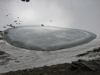
Sandeep, JP and I went down from the ridge to the lake. The lake was completely frozen and there was no sign of any of the famed skeletons. JP tried to go a little further on the ice and ended up drenching his shoe in the cold water. This image of Roopkund reminded me of a perfect half fried egg :-). We spent about 20 minutes there and suddenly saw that some dark clouds had started forming over Junar Gali. Our guide said that it was time to move on and we should get ready for the crossing of Junar Gali.
It was almost plodding in soft snow for the first 200-300 feet and then we reached a point where we had to negotiate the rocks. Now was the part we had been really worried about. We had thought that we would need to fix up ropes here and then the climb should be done using the ropes. However, at this point, I would like to mention, our porters were the real heroes. Without fixing any rope, with the help of our porters we reached on top the Junar Gali and it had taken us all of under 30 minutes to complete the treacherous stretch from Roopkund. In the end, all of it looked so easy that I began to wonder why was there so much of a hype around Junar Gali. It was indeed a great feeling to be here on top at around 16000 feet.


We were the first group on Junar Gali for season. The feeling was exhilarating. This was the tough task and we had all done it together. We spent some time on the top. There are no views from Roopkund as the lake lies in a shallow crater like formation. However, the views from Junar Gali are great. The Mt Trishul ranges looked so close. JP being the faithful Yahoowala, clicked some photos of himself with the Yahoo banner.
While having some chocolates, I felt some snowflakes and that was an indication that the weather was turning bad. We immediately decided to go down. We all thanked the weather Gods for being with us; this climb would have been difficult if the weather had gone sour.
It has been my experience from the past three or four treks that I always feel happy after reaching the pass but after that the descent is always killing and sometimes more challenging than the climb to the pass itself. And the same was true for this climb as well. The descent from Junar Gali to Shila Samudra was a steep downward slope of about 1500 feet. As we started descending down we decided to use the ropes as the initial descent appeared to be very steep. The weather had now turned very bad and it had started snowing heavily.


All the porters went ahead. JP and a porter were going ahead of Sandeep and I. Rajeev was after us followed by Ajay with guide. There was a complete whiteout now and no trail was visible; everything was covered with snow. We were blindly going down. However, we had been in bad weather earlier and had seen such whiteouts during the Kalindi and Bara Bhangal treks. I even clicked some photos taking my camera out of my raincoat.
It took us about one and a half hour before we could see our camps down in the valley. I can’t express, it was such a big relief.

JP, Sandeep and I reached the campsite at around 1:30 PM.


To our surprise, there was another group which had camped there – a group from Bengal greeted us with loud claps. I had initially thought that the tents were of the “Keeda Jadi” guys, however it was indeed surprising to find another trekking group there. They served us hot soup, which was really needed after a long day. We had been walking for close to seven hours.
After talking to Bengali group, we came to know that, they had been trying for Ronti Saddle but had been unsuccessful in their last three attempts. So this time, they decided to do Ronti Saddle first and then climb over Junar Gali and reach Roopkund. They had successfully climbed to Ronti Saddle this year and they would be going to Junar Gali the next day.
We were waiting for Rajeev and Ajay – the weather had turned nasty now and we could not see anything towards Junar Gali. We knew Ajay was with guide but Rajeev was alone so we were little anxious about him. After sometime we saw Rajeev coming down with victory written all over his face. A few moments later, Ajay also came down. He was looking tired. His shoes had given him a tough time as he had slipped couple of times on the snow and rocks while coming down. He wanted to end the trek and go towards Sutol from here, but we all tried to convince him to be with us and in the end he agreed.
It was celebration time for all of us. We opened the Haldiram sweet packet , which we had got for this occasion from Gwaldam.
Shila Samudra literally means “Ocean of Boulders”. The campsite of Shila Samudra (~13500 feet) is at the base of one of the faces of Trishul. This the rock face and I am not sure if anyone has made an attempt of climbing Trishul from this face. We could see the huge icefall and the whole Shila Smaudra glacial moraine of Trishul ranges.

This campsite is also famous for another reason. The whole of the area around Roopkund is famous for different types of herbs. The most famous and popular amongst all these is the herb called “Keeda Jadi” in local language. One strand of this herb can be worth 100Rs. This herb is found in large quantities at this campsite. This is like gold for the villagers around this area who spend a lot of time looking for this herb amongst the melting snow and tall grasses. Our porters were happy at this campsite and I don't think they would have had any issues with a rest day at this place. They forgot they had to cook food etc, all of them went out hunting for Keeda Jadi.

In the evening we also saw a herd of Bharal (mountain goat), near our campsite. There were about 15 individuals in that herd. Before I could get my camera and click some photos, they disappeared in the snow pastures. Sandeep followed the herd for clicking some photos but the goats just disappeared in the snow and moraine.
It had been raining for a while in the afternoon and we all huddled in one tent. Rajeev is doctor by profession and it was nice to have a doctor on the trekking trip. For every small problem everyone used to bother him. In the evening, all of us poured out our health problems to Rajeev and got free consultation.
This was a wonderful day. One the way, we had met lot of trekkers going to Roopkund and believe me hardly any one of them made it till Roopkund. All of them dropped out much before reaching the lake. Before I came to Roopkund, I used to think that it should be possible for first time trekkers to be able to do it. Well I still think it is possible for first timers to come till Roopkund, it is not a difficult trek but a good amount of preparation is required. Trekkers have to fit physically and more so mentally to be able to come up till Roopkund.


Next   Previous

Shila Samudra – Dodang

Today was Sandeep’s birthday. He had grown old on this trek itself. Everyone wished him early morning, from inside the tent itself.
Since yesterday had been a long day for us, we decided to start little late. The Bengali group started at 6.30 AM to cross the Juanar Gali pass. It was going to be a long and difficult day for them. Attempting Junar Gali from Shila Samudra can be more difficult than crossing from the Roopkund side. We all wished them good luck for a successful crossing.
We got ready and started at 9.30AM. It was an easy 20-30 minutes descent to reach the actual glacier of Trishul which gives its name to this area - Shila Samudra. We had to cross this big boulder zone. This is the glacial moraine of Mt Trishul.


It took us more than a hour to cross over to this ocean of stones and then we had to climb a ridge to go towards Dodang. At this point, we had trek along the Nandakini river. We could see the way which went towards Chandaniya Ghat which was supposed to be our campsite for the next day.
On the way JP and Rajeev found the skull with horns of a dead Bharal. Everyone clicked photos with it.


We were now walking along the Nandakini river bed on the boulders. The progress was slow as there was no trail and there was a lot of going up the ridge and then suddenly getting down to the river bed. Everyone slipped at least once on the boulders but luckily no one got hurt. On one such ridge, I slipped from the way and Sandeep quickly arrested my fall. JP pulled me up using his walking stick. On the way again, JP suddenly slipped on the boulders and landed on his back. Fortunately there were no injuries but these were really some scary moments.

We reached the campsite at Dodang (~13700 feet) at around 2.30 PM. The meaning of Dodang is “Two Stones”. The campsite was a small clearing between two very big boulders.


There was a small water creek very next to our camp which was directly coming from the glacier above the camp. After everyone reached the campsite, we realized one of our porters Hira Singh was missing. Nobody had seen him on the way. All of us got worried because yesterday he was having some problems with the altitude. Our guide Mahendar and one porter went back down in the valley to look for him. It was only after about an hour and half that they came back with Hira Singh. We were all relieved on seeing Hira Singh. Hira Singh was not feeling well and was resting on the boulders when Mahendar found him.
This campsite is at the base of Nanda Ghunti. Nanda Ghunti towered above us as we sat near the creek at this campsite.


The trail till Homkund is also very famous for another reason. Every twelve years there is a procession to Homkund called the “Nanda Devi Raj Jat Yatra”. It starts from a village called “Nauty” with a 4 horned ram leading the procession. The image of Goddess Nanda Devi is brought to Bedni Bugiyal and following this very trail brought to Homkund where the marriage of Lord Shiva and Parvati is celebrated. After all the ceremonies are over, the four horned ram disappears in the mountains. Thousands of pilgrims from all the parts of India take part in this yatra. Lots of people walk without any footwear. Homkund is supposed to be very scared place. The next yatra is going to be held in 2012.
Even today also, we met some villages who had come from Sutol to visit Homkund.

We celebrated Sandeep's b'day with Hot Pakoras and Halwa.
It was the coldest night of all the nights on this treks. The small water creek next to our tent was also frozen in the night. The place was again very windy and all our water had frozen. We had another long day tomorrow and had decided to start early at 5 AM. We decided to call it a day.


Next Previous

Dodang-Homkund-Ronti Saddle-Chandaniya Ghat

We already knew that today was going to be tiring day for us and had braced for it mentally. The plan was to go till Homkund (~15200 feet) which was about 4 km from Dodang, then climb Ronti Saddle (~17500 feet), come back to Dodang and after lunch to go down till the next campsite at Chandaniya Ghat.

We got up at 4.30AM and got ready. It was extremely cold and we knew sunrise would take some more time. Finally we started at 5.30M.
From the campsite it was it steep climb for about 30 mins and then it was all scary ridge walks. The widths of the ridges were so small that one can put only one step at a time. We were walking very cautiously. Looking around was a daring task. It was scary and caution was required at each and every step. We decided not to take any chances regarding being cautious and to take the help of the guide wherever required.


I was wondering if the same trail is going to be used for Nanda Devi Raj Jaat Yatra in 2012, with so many people walking together there can be disasters if precaution is not taken. But Mahendar later told us that the administrators for the Yatra would take all the precautions and would get the trail ready for use by the public before the yatra starts.
JP, Sandeep and I were walking together, Rajeev was in the middle and Ajay was coming with guide. While walking on such ridge, Ajay started feeling dizzy. He wanted to go back. We all knew that It was good decision because a wrong step could here could have been life threatening. We saw that Rajeev was also going back with Ajay. It was only later we came to know that they both had pact that they would do the Ronti part together if it all. I think it was a nice gesture on part of Rajeev. We all knew that he was quite keen on going till Homkund. One of the porters went back with Ajay and Rajeev.
We were making good progress towards Homkund. On one of the ridges, the path had broken down completely and we had to take some help from the porters cross it.
We reached the sacred lake of Homkund at around 7 AM. It was an amazing feeling. This was one of those places where one can really feel the presence of the Almighty.

We were very happy that we had made it till this point. There was a small temple where our porters offered pooja. We spent some time here. One of the porters explained the significance of the Yatra and kind of showed us around the Kund. The lake was partially frozen, but the water was very clear and felt strangely felt warmer too. We could have spent an entire day here but realized that we still had a considerable amount of trekking left in the day.
After about 30 minutes, we started for the climb towards Ronti saddle. The climb to Ronti saddle was initially all on boulders. We realised very quickly that we were now walking at more than 16000 feet as we could feel the lack of oxygen.


The best part was that the weather was superb for the climb. It was clear and the we would be getting sunlight soon. It was a tough climb negotiating the boulders and after a while we could see what we thought was the Ronti saddle. It looked so close yet appeared so far.
Since the Bengali group had visited Ronti saddle before couple of days, we thought we would get to see their footmarks in snow and we would follow the same. But strangely we did not get to see any such footmarks. Mahendar then told us that he thought they returned back after the initial climbing the initial boulder zone.
We had left the boulder zone behind us and were now negotiating the hard snow. The snow was slippery hence we were progressing carefully. We zig zagged our way on the slippery snow. At some point we were walking up at a very slow pace just because we were scared of slipping down. After negotiating the snow , we finally reached at top of the saddle at around 9.30 AM. The saddle is at around 17500 feet and is actually looks like a pass between the Nanda Ghunti and Trishul ranges.


The weather was very clear and the views from here were fantastic. Ronti – 1 looked very close to the saddle. Even the summit of Nanda Ghunti looked close and while we were there we heard couple of avalanches on the other side of this massive mountain. We were wondering if we should go a little further as we were neither tired nor fatigued. But we decided to stick to our original plans and decided to spend some time on saddle and then go down. Some of the mountaineers attempt Nanda Ghunti from this face via Ronti saddle.
After clicking photos in different victorious poses, we started our descent down.


It had taken us about 2 hours to climb from Homkund and it took us exactly one hour to get back to Homkund from the top. After negotiating the same scary ridges, we were back to our campsite at Dodang at about 12:15 in the afternoon after having walked for about 6-7 hours.
We were a little tired and after reaching the camp, we came to know Ajay and Rajeev had already left for the next campsite. We had no option but start for the next campsite after lunch.
When we were resting at Dodang the small creek which flowed next to the camp, had stopped in the night and there was no water flowing anymore. Suddenly at 1 PM sharp, we heard the sound of water and water started flowing again in the creek. We knew it was because of the glacial melting above but it reminded me as if we were getting timely water supply from Municipal Corporation every day.
We had a good heavy lunch and started around 1.15 PM for Chandaniya Ghat, our next campsite. None of us wanted to walk on the boulders, so we asked our guide if there was any other route. We could see that there was one route on top of the ridges on our right and it required a steep climb but we were not very sure how much feasible it was to take that route.
We descended to the boulders from our campsite. The river Nandakini was in its full flow at this time of the day and we had to cross the river at an appropriately safe place. We did manage to cross the river after some time.

After this point after having walked for about an hour, we decided to ascend the ridge and tried to do so after holding a very sturdy variety of grass that we had seen growing on the ridges around us. This was a special kind of grass, which I had seen mostly after crossing Junar Gali. After we reached the ridge, we had to trample our way on this grass on the sloping ridge. But it was still better compared to walking on the boulders.

Though there was no marked trail here, but we knew the general direction of the next campsite and it took us another 2 hours to reach the campsite at Chandaniya Ghat (~10500 feet)
The porters had already pitched our tents and told Ajay and Rajeev about our successful climb to Homkund and Ronti Saddle. Ajay and Rajeev came out of their tent and congratulated us. We were all very happy the way the day had ended. It had been fruitful and I was happy that we had made it till Homkund and beyond.
While we were getting down to the camp, the weather had turned bad and after sometime it started to rain. Looking back towards Dodang and Homkund, we could see that the whole of the area was under bad weather and it would be snowing there heavily. Again I think, it was our sheer luck that we got such beautiful weather whenever it mattered. We had excellent views and clear weather at the top of Ronti Saddle.
The campsite at Chandania Ghat campsite was much crowed – and no there were no trekkers there. We were the only trekking group. The rest of the folks comprised all the “Keeda Jadi” hunters who had come from villages like Sutol. It was kind of a base camp for them and everyday in the morning they would go all around in the mountains in search of Keeda jadi and come back in the evening.
This was one of the memorable days of my trekking life and a visit to the sacred Homkund had made it more special.


Next   Previous

Chandaniya Ghat – Sutol

This was going to be another long day for us. Generally people camp at “Lata Khopra” but Mahendar wanted to reach back a day earlier and therefore we had decided that we would camp at Sutol. It was relatively cold morning as it had rained the whole night. The Keeda Jadi guys had already left for their work in the morning. By the time we started, it was 7.15 AM. We had to descend down to the Nandakini river and cross the small bridge which the Keeda Jadi folks have made using Birch logs. It was ridge walking along Nandakini river on loose earth which is more scary then walking on boulders.

After sometime the path entered a thickly forested area. This was Birch and Rhododendron country and we were all enjoying this walk. Nobody wanted to take rest because we were not much tired. It was one of the easier walks on this trek amidst very thick forest. After walking for about 4 hours, we reached the campsite of “Lata Khopra”. This is one of the most beautiful sites I have seen and I was a little sad that we were not camping here.


The campsite is really beautiful and one could just relax with a book in these deliriously beautiful location. If time would have permitted, we would have definitely camped here. After Lata Khopra, the forest became even thicker and we were wondering that trekking in these areas during the rainy season would be nightmare. We also had to deal with a lot of “Tree-crossing” on this trek.
The thick birch forest now gave way thick bamboo forest. The bamboo and fern forest was really beautiful; we saw lot of huge ferns and the cobra lily plants .


We were also starting to feel the heat now. There were quite a lot of creeks on the way and was really helpful because we refilled our water bottles many times. We had been walking for almost 6 hours now and still there were no signs of the forest giving way to villages. I asked our guide how far Sutol was and he gave me a big smile. I understood, we still had a long way to go.
JP had some stuff left from our emergency kit and we thought this time was more than appropriate to use the stuff from the emergency kit. We had some dry fruits which give instant energy, but still were feeling tired. I thought today’s tiredness was because we had had a long day yesterday as well. Finally at around 2 PM which reached a small village called “Tatada”. We decided we would camp here but after reaching the village we came to know, there was no water nearby. All the men of the village had gone for collecting the Keeda jadi and so no one was there to report the water problem as well. The women had to get the water from a water creek which was 2 km from the village. So we had no option but to go to Sutol which was another 3 Km from the Tatada. At least for me, it looked a very tiring walk and I had not had anything to eat since morning. We asked our guide if we could prepare some Maggi and he agreed for the same. After eating the noodles, we got some energy and we started for Sutol. It was an easy descent and it took us around an hour’s time to reach down near the river. On the way met a villager who informed us there was no water in Sutol as well and we decided to camp a little below the village by the river.
In the morning, when we had started from Chandnaiya Ghat, our guide had told us that we could get some place to stay and possibly some hot water in Sutol. But the villager's words disappointed us.
We finally reached our campsite at Sutol (~7800 feet) at about 4 PM after walking for almost 9 hours. After seeing the campsite, we were very happy and we realized that it was a good idea of not spending the night in the village. This was one of the best campsites. The camps were pitched on plain grassy land and the Nandakini River was flowing next to our campsite. There was small water canal and all of us decided to freshen up. It was one of the most refreshing afternoons after a seemingly long time. The water was cold but compared to what we had seen earlier it seemed to very refreshing. The campsite was comparatively very warm too. So all of us just hit the water and felt refreshed.

The Sutol village was at around 100 mts up from our campsite. Lot of children visited us in evening.


It was a celebration time; we were virtually at the end of the trek today. Our guide got some food stuff from the Sutol village and prepared some delicious pakoras. It was a perfect evening. Sandeep and I were enjoying the surroundings with hot pakoras.


I think the life in Himalayas appears to be very beautiful from outside; but I can very well imagine the tough life this people lead. In Sutol, they have a small school but no proper books are available. When we were in Tatada, we met a girl who had broken her arm ; but there were no medical facilities available around for miles. When this people see anyone from civilization, they ask only for some medicines. I hope the condition of the villages on this route and around here improves. I think the Uttarakhand government has lot of plans to develop this area before Nanda Devi Raj Yatra and I sincerely hope that the villagers are benefited from the development.
Our porters had gathered lot of wood and started campfire. We were strolling out in the open till late night – our porters had been on a singing spree and by the time they were done, it was about 10:30 in the night.


Next   Previous